Showing posts with label St. Cuthbert's Way. Show all posts

Tuesday, November 6, 2012

Halfway finished, and across a border

By September 12 (my birthday), we were more than halfway to our destination, and today would mark the crossing from Scotland into England.  Historically, especially before the two kingdoms, England and Scotland, were united in 1603 under James VI of Scotland and I of England, there had been near constant conflict between the two.  This hilly area is now so peaceful, but there was a suggestion in a hotel restaurant that the English and Scots still don't like each other.  They are close neighbors, their food and beers and ales taste the same (to my American tongue).  But the comments of the English couple at the table next to me made me uneasy.  In any event, here are more photos from St. Cuthbert's Way.


At the border:  no customs officials, no border guards, no bureaucracy.  Just a stone wall , some barbed wire, and a wooden signpost out in the wide open sky.

Occasionally the footpath went into a forest, a plantation, really, of evergreens - - very dark and gloomy.  Made me wish for a helmet light like spelunkers wear.

Back in the sunshine, this creature looked like a guardian.  He was near the sheep dip, where two men were dunking sheep in insecticide.


Our English friends, whom we first met in Jedburgh after a fiercely stormy night.  

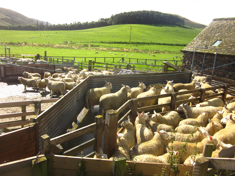
When I first saw golden sheep, I thought it was a special breed.  Turns out they'd just been through the sheep dip.

This large fellow up among the thistles was, we thought, a feral goat.   He certainly was large, shaggy and very handsome.  And I was happy that he kept his distance from us.

A hillside covered in heather.  An amazing sight.

Heather plants are hardy and woody-stemmed.  I'd love to grow lots of it at home, but the climate in Virginia is probably not suitable.

Quite a few of the towns we passed were similar to this:  buildings right at the sidewalk - no yard or lawn.  This is Tisdale House, a B & B where we spent one night.

That bridge is made of brick and stone, it's called Weetwood Bridge, and is a very old listed bridge - which means, I think, that it has historical significance and cannot be changed.
"Flodden 1513" refers to Flodden Field, site of a battle near this bridge, in September 1513 between the Scots and the English.  The reigning monarch of Scotland, James IV, was killed during that battle.  


A handsome gate and gravel drive lead to a large red brick house.

Barbara has found a row of wild blackberries; Sandy appears to be looking for them too.  We found such wild berries  throughout our hike.  September must be their season.

Into a large and well-spaced pine plantation, heading for St. Cuthbert's Cave.

As the rain got heavier, we got closer and closer to the enormous sandstone boulders that formed St. Cuthbert's Cave.

This sign refers to the fact that St. Cuthbert's monks carried his corpse from Lindesfarne (where he died) to Durham to save it from Viking marauders.  The journey took either 6 or 9 years.  And, the legend says that his body was uncorrupted.

Sunday, November 4, 2012

Sept. 10-11 - still in the Borders

These two days were not the longest walks nor were they the shortest.  Mainly they were significant to me because of the occasional proximity to other people - whether farms, towns, or passing us on the way..


Sheep and a farm house or some other building, fallen into pieces in a little valley with a stream running through it.

One of the very good products of Scottish breweries.  Every night I had a different ale or beer.  Not that I know what is the difference.

Out on the loneliness of Cessford Moor Barbara is looking at her map - - are we in the right place? is this the right footpath?  isn't there a signpost somewhere?

Sometimes the footpath was a clearly marked way - created by cows? sheep? a vehicle?

A dry-laid stone wall has no mortar.  That is a sure sign that people have inhabited this place for a long long time.

Sheep everywhere.  Cannot get away from them.  Not necessary: they will run away as soon as I make a move.

Much more domesticated area, with a great variety of lovely chickens, all waiting for someone to feed them.  I think that's why many of them have turned toward me.

That roof is not slate nor shingle.  It is thatched and probably with some kind of reed.   This is in one of the towns called Yetholm - - Kirk Yetholm, I think.

Mobile food - - This truck brings freshly-fried fish and chips to the town green in Yetholm. The man inside is lifting a piece of fish from the HOT oil.  Smelled just great.  I expect to see food trucks in Washington, DC, not in a tiny village in the Scottish Borders.

We could have eaten in the dining room of the Plough Hotel, but the pub seemed so much friendlier and warmer.  And the food came from the same kitchen.

Outside the "Singing Donkey Hostel" (no, we didn't stay there, just passed it on our walk) a clever reuse of worn-out hiking boots.  Very appropriate for this part of the world.
Nearly every day we were passed by a group of about 12 Ramblers (members of a British hiking organization) who were also hiking the SCW.  A bus delivered them each morning and picked them up each afternoon.  Have no idea where they stayed, but it was always good to see a familiar face - even as they "raced" past us.


Monday, October 29, 2012

Days 2 and 3 on St. Cuthbert's Way

There were many things to see - both natural beauties and manmade, and some curiosities.


Thistles may be prickly, but in a group they make a swath of gentle color on the hillsides.

 A deep footpath through quiet and shady woods.  This is Pat - she has long legs and walks fast and is usually way way ahead of me.

J.C. Douglas is very proud of his profession:   Scottish Sausage Champion 2009/10.  I guess I'd put that title on my shop as well.

No matter the size or shape, mailboxes in the U.K. all seem to be bright red.  The Post Office behind Barbara is also a convenience store where we bought some ice cream bars.

Pat is an old hand at crossing stiles and shows Sandy how it's done.

Is it the climate?  Great Britain has some of the biggest beech trees I have ever seen.   They're not so tall as in Northern Virginia, but their girth exceeds  by several times.

I wish that every long hiking day ended with a slice of very lovely and delicious cake.  This one is made with beets, not carrots.

St. Cuthbert's Way passes many abbey ruins.  This one is in the center of the town of Jedburgh.   The red and blue pennants were to mark the route of a cross-Britain multi-day bicycle race set to pass through Jedburgh after we left.

This is Monteviot Bridge, a pedestrian bridge that crosses the Teviot River.

Dere Street is the present-day name for a road originally laid out by the  Romans some 2 millenia ago.   But it is definitely no longer a "road" or "street", but a very narrow footpath through long, wet grasses.  Romans built straight roads; on the map this is straight but in fact it wiggles back and forth.  But is thankfully level.

Tuesday, October 2, 2012

St. Cuthbert's Way

Four friends took a wonderful seven-days walk in mid September.  It was 62 miles long, through the Scottish Borders.  The route was probably an old pilgrimage route from medieval days - - we passed several former monasteries or abbeys that had been ravaged by time after Henry VIII ordered them closed in the 1540s.  We walked from West to East, from Melrose to Holy Island - from Melrose Abbey to Lindesfarne Abbey.
The walk is named after a 7th century saint. Cuthbert was a native of the Borders who spent his life in the service of the church. He began his work at Melrose Abbey. He achieved the status of Bishop, and when he died he was buried on Holy Island. He was called a saint eleven years after his death, when his coffin was opened and his remains found to be perfectly preserved.
Here's a pictorial history of the walk, which  is called St. Cuthbert's Way [SCW]:


The "official" beginning of the SCW is the churchyard gate at Melrose Abbey


This is Melrose; we spent 2 mights here - most of the towns where we stayed looked like this: 2-3 story buildings, made of stone, several centuries old, ground floor shops, flats above, narrow streets. Melrose Abbey is a popular attraction, managed by Historic Scotland (I think) and so it's a bit more crowded and up-to-date than some others.


We walked and hiked and climbed up and up.   The Eildon Hills (rather steep) were the first obstacles, not very high, fortunately.   Barbara's looking down at how small the town appears.

Salmon fisherman in the Tweed River.  The SCW follows this for about 2.5 very large bends.  It had been suggested that permits to fish the Tweed for salmon are very expensive, which may explain why the river wasn't full of fishers.


The Roman helmet signifies that we are now on Dere Street, laid out by Roman army 2000 years ago.  On the map it is a straight line of a mile or two.  In reality it wiggles and twists and is overgrown with long wet and annoying grass.  That's Pat pointing out something.


These are outbuildings from a very large estate.  They've been converted into an arts center, children's enrichment center, tea room, art gallery, visitor center.  It's called Harestanes and we enjoyed the tea room while awaiting the taxi to carry us to our B & B.
Here is what sheep do.  They munch and munch, heads down on the grass.  When one sees me, it stares, motionless.  When I raise my camera, it hightails it away.   And all the rest follow suit.  Every one of them.  All running away.


This was a milestone not to be forgotten.  It always felt like bigger hills and that the end would never come.  The prior photograph shows us struggling to keep the constant wind from tearing off hats and chilling hands.  Blessedly, the wind was at our backs.


To American ears, these names seem (to be kind) odd.  Would I choose to live in a place called Sourhope?  too depressing.  And what would be the derivation of Cocklawfoot?  At least, Belford on Bowmont would be different from, say, Belford on Tyne or Belford on Thames.

Dogs in the pub were common.  This fellow sat or lay, bored, the entire time we were there.  Pub food seemed to be fairly uniform:  steak and ale pie, fish and chips, roast lamb shank. chicken curry.  Occasionally a treat:  seared salmon; lamb loin chops.  My personal favorite was also a one-off:  Trawler pie (like shepherd's pie but with salmon, prawn, scallops).


A border without border control.  As my son pointed out "You are on the right side of the border."  And I think this was my 72nd birthday but wasn't sure.  Time didn't seem the same without clocks everywhere.


The footpath led through many tree plantations.  This pine plantation surrounded St. Cuthbert's cave, a very minor but physically large attraction.

St. Cuthbert's cave is a large "room" on the hillside, beneath monstrously big limestone boulders.  Without a flashlight, I didn't explore.  We were greeted by the Ramblers who had passed us every day (being British, they don't poke along), and who were "killing time" until time to meet their van in the next town.

To get to this point - on a chilly and damp morning-  we crossed a highway, through fields and along farm roads, across a very busy train track, a stream and then a field, and eventually here.  The end is in sight.  The causeway is to the right of the signs.  My great fear was that we would miss low tide and have to wait six hours to cross.  We made it.


In earlier years (pre-causeway) pilgrims walked across the sands, like these two.  Poles mark the way.  Somewhere out there is a "refuge" - small room elevated about 12 feet above the sand.  We did NOT walk the sands.


The village of Holy Island and our hotel - large white bldg. behind the red roofed one - are just beyond the small harbor.  The castle of Lindesfarne stands on a very high rock (part of an extinct volcano?) behind the photographer.


Here's the same harbor from the hotel's lawn, and that's the Lindesfarne Castle high atop its dark rock.  Looks forbidding, doesn't it.
This bus runs once weekly in September and every 10 days in the next six.  The only time it runs daily is in Tourist Season.  It took us to Berwick where the next adventure began with buying a bus ticket in a train station.  It seems the train doesn't run on weekends because of track work (Oh, shades of Washington's Metro!) 

And that was the end of our too-fast visit to the Scottish Borders. I'd love to go back and revisit some of the towns, the moors and, yes, even the hills. It was very tiring but also very exhilarating and I have good feelings about having done this.