Showing posts with label Riquet. Show all posts

Monday, October 28, 2013

Southwest France - day two of WCC13

Sept. 17 - - This was a day I was eager for.  After four early presentations at the conference, we boarded the coach and headed off to view and learn about the water feeder system into the St. Ferreol Reservoir at Revel.  The Reservoir was created by a very long (780 m.) cut stone and concrete dam supported by a high (35 m.) earthen dam covered (and protected) by trees.  Those trees by law cannot be cut.
At the entrance to S. Ferreol's building.

A very good, clear guide led us up to the top of the dam.  As we stood by a sluice gate, she delivered a rather long history and detailed explanation of what Riquet built and why the original construction was inadequate.
Next to our guide is the sluice gate, behind her is the dam with its wide walkway, the great reservoir, and in the far distance the Montaigne Noir.
Riquet's accomplishment was so inadequate that Vauban later corrected the situation by making the dam several meters higher.  We saw the sluices, the flood spillway, and, in addition, noted three mountain crests that make up part of the Montaigne Noir.  I hope my photos of them in the mist are adequate.
From the sluice in the prior photo, water flowed down and out here. 
Also at that level were two plaques, one honoring Pierre Paul Riquet, the ingenious tax collector who persuaded the French King, Louis XIV (through his minister, Colbert) that the canal could be constructed.
Why was there a plaque honoring Thomas Jefferson?  How's your French?
A symbol of Franco-American friendship.  In addition to his political roles (Ambassador, President), he traveled through French territories and promoted French patrimony, including architecture, "terroir", culture, played a key role in the French constitution and in the Declaration of the Rights of Man and of Citizens.  Erected on the 220th anniversary of the French Revolution.
Another sight to see was not created by Riquet but was mid-19th century - - a fountain that shot about 25-30 meters up.  Kind of like a manmade "Old Faithful".
The fountain was surrounded by too many leafy trees!
The site also contains an interesting shop and museum.  One could buy, among other things, a map book of the Canal du Midi similar to mine from 2009.  Of interest to me in the museum were some of the tools used in the 17th century:  a shovel, a basket woven of reeds or vines for carrying away soil (no wheelbarrows then), a rudiemntary and odd-looking early surveyor's tool.  This is all housed in the former residence of VNF personnel.
One wonders if Riquet lived here while the reservoir was being constructed.
Then back on the bus to drive to Castelnaudary for lunch.  As we drove into the large parking lot next to the meeting place, I noticed the store "Pays d'Oc" that sold us some cheese, milk, yogurt in 2009. Unfortunately there are no photos from the Castelnaudary stop.

At long last we set off to locate and explore the so-called summit at Naurouze. This was where it all came together; the various rigoles fed into St. Ferreol, and from thence down to Naurouze's octagonal basin (now an octagonal channel) and into the canal feeder.
This structure was built at the same time as the canal and allows surplus water to flow towards Fresquel, the basin of Naurouze. Gates serve to modulate the quantity of surplus water as well as for the emptying of the basin. Today siphons on the left bank of the epanchoir, automatically regulated the level of the basin to a determined height.
I could finally see the last element of feeder water flowing into the Canal du Midi, and could understand much better the entire system of collecting water from various mountain streams and directing them into the channel for delivery to the canal at its summit level at Naurouze.
Although this sketch from 1697 shows the basin, what now exists is an octagonal channel. Water flows now from a point between the upper Ocean Lock and the lower Mediterranean Lock.
Flowing out of the basin toward the Canal du Midi.
Kind of like a "continental divide" - the summit marked the high point in the canal from where water flowed either to the Atlantic or to the Mediterranean.
The channel on the left is incoming water; the channel on the right is the Canal du Midi, which continues in two directions, east to the Mediterranean and west to the Atlantic.


From this watershed, the water flows through those concrete slopes and flows either left to the Mediterranean Sea or right toward the Atlantic Ocean.
That boat is headed "up" the Canal du Midi toward the Ocean Lock and the city of Toulouse.
This day, combined with the pre-conference visits and the places we went on Sunday and Monday, completed my visit to and experience with the Canal du Midi.
The title translates to:  The Parting of the Waters.  I.e., The Watershed
Back in Toulouse, we had time to rest a bit and change clothes for the Mayor's reception in the city hall (i.e., Le Capitole).  The building is a very large 17th or 18th century structure.  The reception was up a grand flight of stairs, in the "Salle des Illustres" a long high-ceilinged room that reminded me of the very long Hall of Battles at Versailles chateau, with enormous paintings on every wall.
I believe that on the platform are two city councilwomen, the mayor and deputy mayor of Toulouse, a man with important connections to the Canal du Midi, and David Ballinger, who is President of IWI.  Our translator/guide, David Edwards-May, is standing to the left.
The most dramatic of the paintings memorialized the visit to Toulouse by Pope Urban V, where the local count, Raymond de St-Gilles was undertaking the first Crusade to "liberate" Jerusalem from the "Infidels". Many speeches in French by the local officials, all of which were translated by David Edwards-May. The local version of Champagne and hors d'oeuvres were abundant.
Canapes in the great hall, with glasses waiting to be filled.
This fellow used three different bottles for each glass - why?


We four women (me, Kerry, Pat, Barb) dined together in Pizza Pino nearby - of three cafes next to each other, it was the busiest.  And the reason it was the busiest:  good food, not expensive, casual atmosphere, and very prompt service. And it was a delight to get into my bed at a reasonable hour.

Southwest France - day three of WCC13

Sept. 18.  I was not a good delegate today.  I blew off nearly all of the presentations to catch up on this record, with some help from the guidebook that David Edwards-May and Tom Grasso prepared, the Conference program, and my own photos.  We were scheduled to board buses at 16:00 (i.e., 4:00 PM), but because of bad weather at Bonrepos, we were asked to delay.  Not a problem.  I doubt that any of the various sessions and/or presentations began or ended as scheduled.
I called this the back side of the chateau.
In any event we finally set off.  Bonrepos was the chateau belonging to Riquet and the site of his "hydraulic machine" - a kind of experiment to see if his scheme of feeder canals and reservoir would work.  The chateau is looking as if it had fallen on hard times - - and it had.  The village purchased it in 2005 or 2006 and has cleared the grounds and cleared the hydraulic machine.  That "test site" is downhill from the chateau.
Our guide was an Englishman, Dudley, who came to Toulouse four decades ago to work for Airbus. Now retired, he is a great font of knowledge about Riquet and his hydraulic machine.
Dudley, our guide, explaining the glaciere (ice house).
There we saw a drained basin defined by brick walls of about 400 feet long.  The basin was about the size of a neighborhood baseball field.
The railing just behind trees on the left identifies the spot where the basin drains into the much lower sluice.
Along the perimeter, above the brick walls, a pathway ran along the circumference.
My best view of the brick wall that defined the basin's perimeter..
We could see the lower drain where water ran out and down a sluice and out of sight.
That little dark triangle opened into the sluice.
Rather than return via the steps, we walked around the empty basin and began to walk up a slightly muddy, long, slippery slope. It got muddier and slipperyier.
One of us slipped on the mud; getting vertical again was tricky.
Several of us began sliding. I moved from the lower left side to the higher right side, hoping to find better footing. I struggled along with a friend; we kept each other company as we slowly and carefully made it to level ground. That's where the "slippery slope" sign was posted.  Humph.  Wrong place.
"Attention:  danger.  Slippery slope"
The chateau had been opened for us. It is owned by the village of Bonrepos since about 2005; the village has cleared vegetation from the hydraulic machine area and around the chateau. The village has also worked on the interior of the chateau. The building is stable, but could use some cosmetic work and incidental repairs.
This entrance is in good shape; the stucco needs repair; the lintel above the doorway is missing some bricks. But look through the door through the center hall to the opposite side of the chateau.
Its floorplan on the main floor was simple: a wide center hall flanked on each side by two large rooms. Some of the rooms were furnished sparsely; the parquet floors would be quite beautiful if they could be repaired, cleaned and painted.
I was impressed with the condition of the crown molding, the panelling, and those two pilasters.
Other rooms had dresssmaker dummies clad in 18th century clothing from simple to grand.
A lady's morning dress

And things for sale - - if I had realized that the proceeds from any sale went toward the refurbishing, I would have spent many of my euros.

The interior rooms were in pretty good shape.  Parts of the exterior clearly need assistance.
Not just the brick plinth needs repair; many of the shutters are broken and peeling.  But the moat wall appears to be sound - people are sitting on it.
Dinner was to be served in the adjacent brick Orangerie. The village has done an excellent restoration job on the Orangerie.
I found a pre-restoration photograph of the Orangerie.  
After all, it is rented for dinners, wedding receptions, conferences, and so on - a significant source of income for the restoration project.
The Orangerie is behind the two tents (the tents must have housed the caterer's kitchen/pantry.
This building had very large windows on the South side, fewer than I had expected.  We waited outside until the clock struck eight - and it was raining lightly.  Glad we were that it was not also muddy.
We were forced to wait outside the glass folding doors until exactly 20:00 hours (that's 8:00 PM in USA).
This was a lovely meal, with interesting appetizer using odd mushrooms, the main course was filet and potatoes, and the dessert was a kind of mousse.
Several kinds of wine, including the WCC 2013 variety.

My tidy filet with two types of potatoes - it was all good.
During dinner, there were a few speeches.  One caused great hilarity among the French-speakers.  Isabel Hardy, deputy mayor of Toulouse, said that we were there thanks to Pierre Paul Ricard (not Riquet). The hilarity was explained in the translation - - Mr. Ricard was the creator of "Pastis" and not of the canal.
A nice view of my table and the interior of the building.

Wednesday, October 23, 2013

Southwest France - day one of WCC13

Sept. 16:  Last night Barb and Pat had made their way to the IWI Annual General Meeting at the conference center.  So this morning the mother hens collected their chicks and led us through the complexities of the Metro system and into the Espaces Vanel conference center,
From the 6th floor terrace of the conference center we looked down on the large white statue of Pierre Paul Riquet.
 up to the 6th floor check-in at the conference, where we received a tote full of informational brochures, a gift of local wine, and the conference Id. badge.
Here are Susan, Chris, Bill, and Dan, complete with badges and one wineglass.
Of course, there was a long session of speeches by various officials of the city of Toulouse, of  the Association of communes of the Canal of Two Seas, the Inland Waterways International, French National Waterways, The Region Midi-Pyrenees, and, of course, the Minister of crafts, trade and tourism.  Following these officials, the first session began with a power-point talk by an official of French National Waterways on the plane tree replanting project.  I've written earlier about what we'd seen on our several visits to the Canal, where trees have been removed, or marked for removal. (http://www.blogger.com/blogger.g?blogID=3253909292900505499#editor/target=post;postID=2980389158855619024;onPublishedMenu=allposts;onClosedMenu=allposts;postNum=3;src=postname. A shame that the beautiful, cool, green shady vault will be no more.  The replanting is moving apace, but trees take a while to grow tall and stately.  I think I won't see the like again in my lifetime.

One of our members delivered a paper on Thomas Jefferson's visit to the Canal du Midi during his term as the United States Minister to the Court of King Louis XVI.
Mr. Jefferson ventured to the South of France and report to Pres. Washington on agriculture and commerce, and particularly the Canal du Midi.  The carriage wheels were removed and the carriage was set on a canal boat for his journey of nine days.
Papers were presented in sessions of four or five power points, and each session was broken by coffee breaks or lunch.
The buffet dessert table held these tasty morsels.

Today's ended around 3:30.  We walked from the conference center to a landing stage on the Canal for a boat trip to Saint Sauveur where several waterways companies were exhibiting (e.g., a floating sewage pumpout station, publishers Euromapping and e-canal Ltd, marine boilers, and dredging specialists). Also, many number of canal barges were moored for the rally.
From the center of a bridge, I could see the various boat-rally vessels.
We reboarded the boat and cruised up the canal to Port Sud at Ramonville-St-Agne, for a visit to the large new marina, some aperitifs, and a speech by the local mayor about plans for the marina and its new dry dock.
Was this part of the Ramonville drydock?

Beneath the tent were canapes, aperatifs, and speeches.

Back through the rain to the boat, and continuing on a short distance to Le Mas des Canelles for a very nice but long three-course dinner. Le Mas has a newly finished landing and access path, so despite the rain, we didn't have muddy shoes. 

A large 19th century converted farmhouse.
Half of us in this room, the other group of delegates were in a second room.
Ramonville and Le Mas are both in the countryside outside the suburbs.  It was pleasant to cruise however slowly past trees and shrubs and moored boats.
Scenery is much more immediate when viewed from a slow-moving boat.

The paddlers moved aside to make room for our passage.

Following dinner, we boarded motor coaches for a ride back to Toulouse that was appreciably shorter than the boat cruise. 

Monday, October 14, 2013

Southwest France - visiting more Canal sites

Saturday morning, September 14 - - up early to try and photograph sunrise over the canal that faced our hotel.
Two small boats heading up the canal toward the larger harbour.
Then bags down by 8:15, breakfast, hop on the coach, and off to Narbonne.
Andre, our driver, works hard every morning loading the luggage.
It was a Roman town and had a Roman canal to link the town with the sea via the river Aude.  Eventually the river's course altered and abandoned the town.  In the 18th century a new canal (de la Junction) was built to connect Narbonne with the Canal du Midi, and an older canal (de la Robine) connecting Narbonne with the Mediterranean Sea was later linked with both La Junction and a portion of the Aude River, resulting in something called La Nouvelle Branch.  As we did not carefully inspect these waterways, we will take David's word for it (David being our guide/leader/friend David Edwards-May).
The weir is at the right, and the modern lock is to the left.
We had time in Narbonne for a walking tour.  Barbara and I opted to ride the local Navette (shuttle) to get oriented to the town, a ten minute round-trip, then we set off walking.
A handy shuttle bus, free of charge.
We saw the "Roman" weir next to a more modern lock,
This is the "modern" lock; to the right is the original channel that ended at the weir pictured two photos up.
walked to and then on the remnant of the Via Domitia (!)
Young children on an ancient road

Someday I will translate this message.
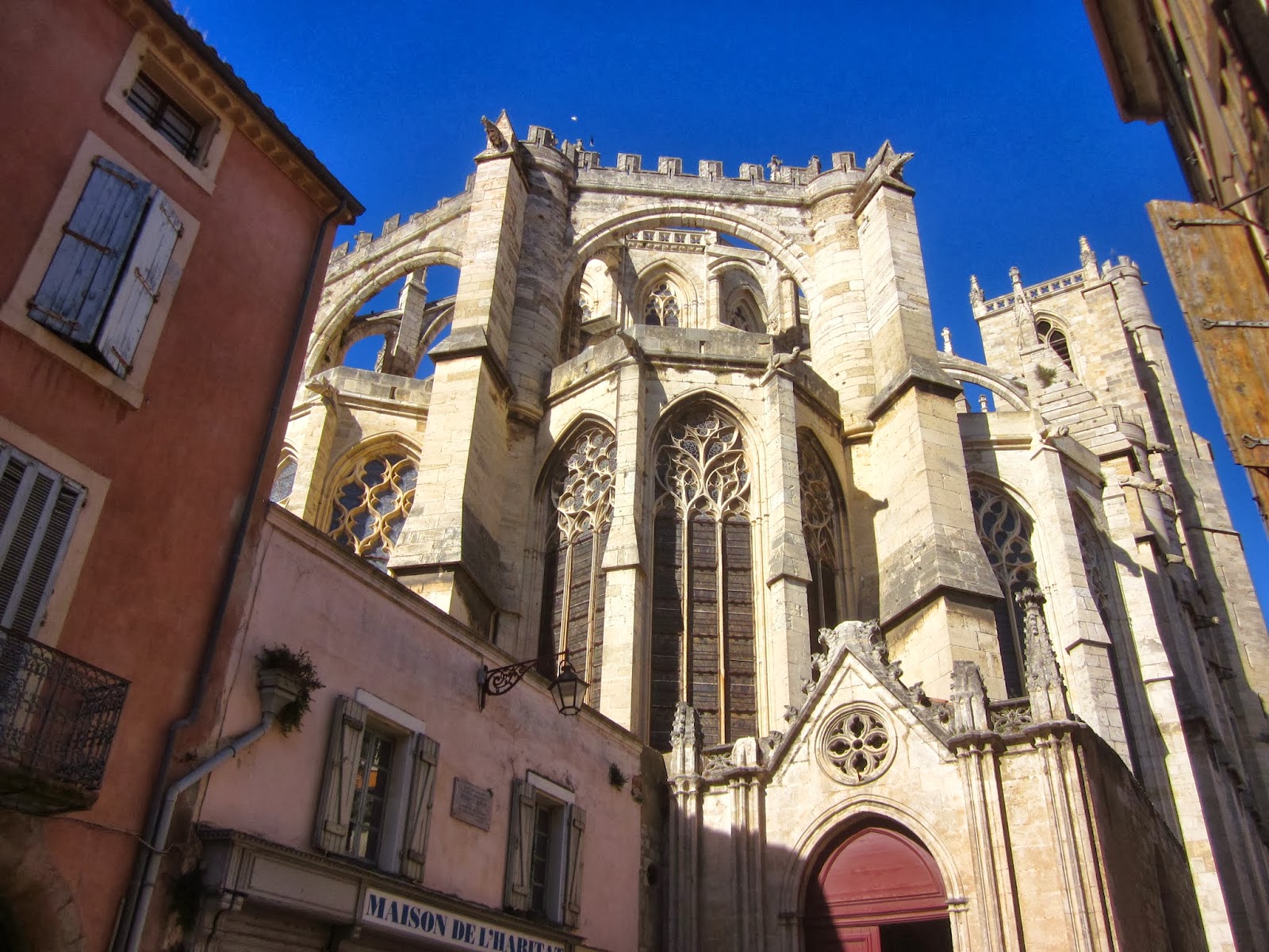
explored Narbonne's cathedral,
The cathedral is hemmed in on all sides by the city, no great plaza nearby.
which is missing about 4/5th of its transept and nave so that it looks half-abandoned.
The only entrance that was open was behind the fence

This is like viewing a ruin that's been kept in good repair.

We also saw and used a totally automatic and totally free toilette.
I had seen one of these years before in Paris. There was a fee, in francs (pre Euro days).
We drove to the canalside village of Le Somail for lunch at a restaurant, L'O a la Bouche.  This town was built as an overnight mooring on the Canal du Midi, and it's a nice, attractive place.
The little hump-back bridge is next to a small chapel built into the canal.
We ate outdoors under sunshading umbrellas.  Choice of lunch was a tagine of lamb and couscous or pork cheeks with potatoes. Anticipating that I may never again meet pork cheeks on the menu, I chose that, to my regret.  The first course and the dessert were quite nice, however.
An incredibly warm day, good food, and good friends.
Between courses, I got up and walked downstream a bit.  Many boats were moored on each side of the canal.  I saw a straight line of either large ducks or small geese swimming in a line across the water toward me.  Were they Mother and children?  or was it just follow the leader?
quack quack - did they think I would feed them?
We were to be driven to a village that was less than 1 km. from the Pont-Canal de Repudre, the aqueduct built by Riquet in 1676.  Unfortunately, the coach had to cross a bridge whose access meant a 90-degree right turn.  But the coach was too big.  Andre, the driver, had to carefully reverse back around the turn without damaging the bridge or the curbstones or the bridge railings OR the bus.  Sadly, one large door to the storage bed on the driver's side was badly bent.  They could not be unbent, but could be kept closed thanks to the bungee cords in Duncan's backpack.

The plan to drive us close to the Pont-canal was scrapped, and we would walk the mile or so down the towpath to see it.
Bill and Chris Holdsworth heading along the towpath.
It's important because it was designed and built directly under Riquet.  Other stream crossings were either culverted or were crossed at grade; these were changed to aqueducts sometime between 1680 and 1690.

One advantage of taking this walk was a very close-up view of the plane trees' damage. (My post for the previous day includes photos taken from the canal boat.) In some areas the trees might be totally dead and marked with three vertical blue dots, or clearly afflicted by the fungus or canker, and marked with a white X or healthy for now and marked with a green X.  There are said to be 42000 plane trees along the 240 km length of the Canal.  There is no known cure or treatment for the fungus, so as trees become infected they and their next several neighbors on each side are removed and burned on the spot.  In some places on this one-mile walk we passed stumps, dead trees, clearly infected trees, as well as beneath the welcome shade of fully-leafed trees.  The contrast was quite surprising; the prospect of a future without these beautiful and magnificent ancient trees is profoundly sad.

We headed along and came to the Riquet aqueduct across the Repudre (a little creek far below).  Many in our party climbed down the slope to get a good view (i.e., photo).
There is a plaque on this wall, commemorating Pierre-Paul Riquet, who built this structure in 1676.
I had forgotten about the long overflow on the far side of the aqueduct.  Three boats had preceeded us up the Canal and their wakes caused an overflow over this section.  Hence the wet paving stones rather than natural soil and grass typical of the towpath.
The paving stones, of course, prevented the towpath from being eroded by the wake of passing boats.
We were running late (something that became a recurring theme), so went directly to La Cite of Carcassonne.  This is a true medieval city, enclosed by a double rampart.  In the late 19th century, it was "restored" by Viollet-le-Duc, hence the heavy slate roofs on the towers, conical in shape.
This is a view from the hotel's terrace, inside the ramparts of La Cite.
We arrived late in the day when many day-trip visitors were leaving, so walking uphill against a flood of people was pretty slow.  Some of us went to walk through the Chateau Comtal and the ramparts. I chose to find my room and to relax.   The bags, somehow, were conveyed to the hotel, and to each room.  Hotel La Cite is very luxe and lovely; I think there was probably a staff person available for each guest everywhere.
The room is much larger than this photo shows.
My friends and I decided to dine at the cafe near the big well (L'Auberge du Grand Puits) where we'd dined in 2009.  Nothing seemed to have changed.  Same menu, same prices.  In 2009 I had "thon" (tuna), and it was again on the menu - - but not in the kitchen that evening.

Photos of L'Auberge du Grand Puits, Carcassonne
The well ("puit") is the large round structure to the left of the person in the striped shirt.
The Grand Puits before customers show up.
Word had come down from David Edwards-May for suitcases outside rooms by 7:15 am and ready to board the coach outside the Porte Narbonnaise by 8:15.  Hmm.  Could it be done?