Monday, October 29, 2012

Days 2 and 3 on St. Cuthbert's Way

There were many things to see - both natural beauties and manmade, and some curiosities.


Thistles may be prickly, but in a group they make a swath of gentle color on the hillsides.

 A deep footpath through quiet and shady woods.  This is Pat - she has long legs and walks fast and is usually way way ahead of me.

J.C. Douglas is very proud of his profession:   Scottish Sausage Champion 2009/10.  I guess I'd put that title on my shop as well.

No matter the size or shape, mailboxes in the U.K. all seem to be bright red.  The Post Office behind Barbara is also a convenience store where we bought some ice cream bars.

Pat is an old hand at crossing stiles and shows Sandy how it's done.

Is it the climate?  Great Britain has some of the biggest beech trees I have ever seen.   They're not so tall as in Northern Virginia, but their girth exceeds  by several times.

I wish that every long hiking day ended with a slice of very lovely and delicious cake.  This one is made with beets, not carrots.

St. Cuthbert's Way passes many abbey ruins.  This one is in the center of the town of Jedburgh.   The red and blue pennants were to mark the route of a cross-Britain multi-day bicycle race set to pass through Jedburgh after we left.

This is Monteviot Bridge, a pedestrian bridge that crosses the Teviot River.

Dere Street is the present-day name for a road originally laid out by the  Romans some 2 millenia ago.   But it is definitely no longer a "road" or "street", but a very narrow footpath through long, wet grasses.  Romans built straight roads; on the map this is straight but in fact it wiggles back and forth.  But is thankfully level.

Thursday, October 25, 2012

Borders and St. Cuthbert's Way, Sept. 6-7, 2012

I took so many photographs on my September trip to the Scottish Borders.  Here are few more, from our first two days - in the town of Melrose.
The interior of Melrose Abbey, a relic of the English Reformation.

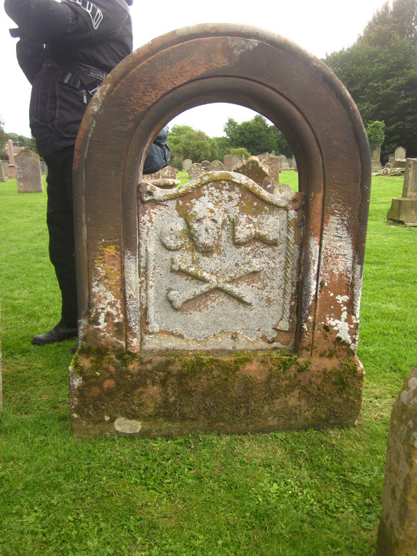
Many ancient grave markers bore the skull and crossed bones - I doubt they signified that the decedent was a pirate.

Sandy's cell phone gave her fits, so she tried the old-fashioned  kind.

EVERY fisherman's prayer - the Borders have apparently some great rivers for  salmon fishing, esp. the Tweed River.

"Full Scottish Breakfast" = eggs, mushrooms, black pudding, sausage, fried tomato, bacon,  potato scone.   I found that once was enough.  Later mornings I eliminated several items.

Looking down on Melrose from one of the Eildon Hills (which we hiked up as the first of several).

Tuesday, October 2, 2012

St. Cuthbert's Way

Four friends took a wonderful seven-days walk in mid September.  It was 62 miles long, through the Scottish Borders.  The route was probably an old pilgrimage route from medieval days - - we passed several former monasteries or abbeys that had been ravaged by time after Henry VIII ordered them closed in the 1540s.  We walked from West to East, from Melrose to Holy Island - from Melrose Abbey to Lindesfarne Abbey.
The walk is named after a 7th century saint. Cuthbert was a native of the Borders who spent his life in the service of the church. He began his work at Melrose Abbey. He achieved the status of Bishop, and when he died he was buried on Holy Island. He was called a saint eleven years after his death, when his coffin was opened and his remains found to be perfectly preserved.
Here's a pictorial history of the walk, which  is called St. Cuthbert's Way [SCW]:


The "official" beginning of the SCW is the churchyard gate at Melrose Abbey


This is Melrose; we spent 2 mights here - most of the towns where we stayed looked like this: 2-3 story buildings, made of stone, several centuries old, ground floor shops, flats above, narrow streets. Melrose Abbey is a popular attraction, managed by Historic Scotland (I think) and so it's a bit more crowded and up-to-date than some others.


We walked and hiked and climbed up and up.   The Eildon Hills (rather steep) were the first obstacles, not very high, fortunately.   Barbara's looking down at how small the town appears.

Salmon fisherman in the Tweed River.  The SCW follows this for about 2.5 very large bends.  It had been suggested that permits to fish the Tweed for salmon are very expensive, which may explain why the river wasn't full of fishers.


The Roman helmet signifies that we are now on Dere Street, laid out by Roman army 2000 years ago.  On the map it is a straight line of a mile or two.  In reality it wiggles and twists and is overgrown with long wet and annoying grass.  That's Pat pointing out something.


These are outbuildings from a very large estate.  They've been converted into an arts center, children's enrichment center, tea room, art gallery, visitor center.  It's called Harestanes and we enjoyed the tea room while awaiting the taxi to carry us to our B & B.
Here is what sheep do.  They munch and munch, heads down on the grass.  When one sees me, it stares, motionless.  When I raise my camera, it hightails it away.   And all the rest follow suit.  Every one of them.  All running away.


This was a milestone not to be forgotten.  It always felt like bigger hills and that the end would never come.  The prior photograph shows us struggling to keep the constant wind from tearing off hats and chilling hands.  Blessedly, the wind was at our backs.


To American ears, these names seem (to be kind) odd.  Would I choose to live in a place called Sourhope?  too depressing.  And what would be the derivation of Cocklawfoot?  At least, Belford on Bowmont would be different from, say, Belford on Tyne or Belford on Thames.

Dogs in the pub were common.  This fellow sat or lay, bored, the entire time we were there.  Pub food seemed to be fairly uniform:  steak and ale pie, fish and chips, roast lamb shank. chicken curry.  Occasionally a treat:  seared salmon; lamb loin chops.  My personal favorite was also a one-off:  Trawler pie (like shepherd's pie but with salmon, prawn, scallops).


A border without border control.  As my son pointed out "You are on the right side of the border."  And I think this was my 72nd birthday but wasn't sure.  Time didn't seem the same without clocks everywhere.


The footpath led through many tree plantations.  This pine plantation surrounded St. Cuthbert's cave, a very minor but physically large attraction.

St. Cuthbert's cave is a large "room" on the hillside, beneath monstrously big limestone boulders.  Without a flashlight, I didn't explore.  We were greeted by the Ramblers who had passed us every day (being British, they don't poke along), and who were "killing time" until time to meet their van in the next town.

To get to this point - on a chilly and damp morning-  we crossed a highway, through fields and along farm roads, across a very busy train track, a stream and then a field, and eventually here.  The end is in sight.  The causeway is to the right of the signs.  My great fear was that we would miss low tide and have to wait six hours to cross.  We made it.


In earlier years (pre-causeway) pilgrims walked across the sands, like these two.  Poles mark the way.  Somewhere out there is a "refuge" - small room elevated about 12 feet above the sand.  We did NOT walk the sands.


The village of Holy Island and our hotel - large white bldg. behind the red roofed one - are just beyond the small harbor.  The castle of Lindesfarne stands on a very high rock (part of an extinct volcano?) behind the photographer.


Here's the same harbor from the hotel's lawn, and that's the Lindesfarne Castle high atop its dark rock.  Looks forbidding, doesn't it.
This bus runs once weekly in September and every 10 days in the next six.  The only time it runs daily is in Tourist Season.  It took us to Berwick where the next adventure began with buying a bus ticket in a train station.  It seems the train doesn't run on weekends because of track work (Oh, shades of Washington's Metro!) 

And that was the end of our too-fast visit to the Scottish Borders. I'd love to go back and revisit some of the towns, the moors and, yes, even the hills. It was very tiring but also very exhilarating and I have good feelings about having done this.


Tuesday, August 28, 2012

Pay no attention . . .

. . . to the weatherman.  I had planned on hiking today with friends, my usual Tuesday hike.  We were going to one of my favorite places:  Sugarloaf Mountain, near Dickerson, Maryland.  I always used to get lost when going there, until I realized that the local Interstate Highway (I-270) was the best bet. 
Now Joe likes New Orleans and Mobile, both places he knew well when we were young.  And he always gets eager when some hurricane looks to threaten those places.  So this summer, this week, there's hurricane Isaac and there's also the Republican party having a big nominating convention in Tampa, down in Florida.  And there were fears that Tampa might be adversely affected by Mr. Isaac.  Sunday and Monday Joe put on his channel-flipper gloves and likely did not watch anything more than weather reports, some on site, some off site, looking for word of New Orleans and Mobile.   After all, this week is the 7th anniversary of hurricane Katrina. 
What has this to do with Tuesday hiking?  I know not why the local weather reporters got so crazy, but they were predicting showers, sunshine, thunderstorms, partly cloudy - - not a one of them consistent with another.  And so this morning, bright and early - - well, not bright.  That was the problem.  It was cloudy, and it was humid, and I dithered around and finally decided.  If I were on a Through-Hike on the C & O Canal or if I were hiking on one of Scotland's lovely long-distance footpaths, I would soldier on through rain, wind, sleet, whatever.  But I'm not there and not doing that.  And rather than drive 35 miles just to walk in what might turn into a thunderstorm, I decided to stay home.  Particularly after Pat reminded me of the time years ago when 4 of us arrived at Sugarloaf's West Parking Lot just in time for a deluge to drop upon us and turn the steps to the summit into a waterfall. 
No walking today.  But how silly that was.  Yes, the early morning was cloudy and humid, but the day progressed (as it always does), and became a bright, sparkling day with shadows so crisp and sharp you'd think they were cut with scissors. 
So I got things ready for the Scotland trip next Wednesday.  Not quite a wasted day.  But no walking today.  How'm I supposed to get my lower extremities ready for walking 7-12 miles/day if I'm not doing some of that now?  Well, there are still 7 days to go.

Sunday, July 15, 2012

An Organic Farmers Market in Paris


Farmers' markets fascinate me. The idea that a kind of society has grown up linking urban dwellers with food growers and producers. The weekly markets have drawn me since I first learned of the one at Arlington's courthouse area several decades ago. So as I began to read about the organic market on Blvd. Raspail in France, and realized that it is almost next door to the familiar apartment, I promised myself that I'd find it. And this summer I persuaded my friends that it would be a treat.   Just a few blocks from where we were staying.

What follows are a series of photographs that I took in late June this year.

my friends, from right to left:  Barbara, Debbie, Ashley, 3 generations, 1 family

fetching veggie presentation

these are all soft cheeses

"try this fresh apricot"

many sizes and varieties of honey

a delight to lovers of confiture (that's jam, to Americans)


someone with a refined sense of style and order did this

no, despite my love of charcuterie, I bought nothing here

My thought on taking this pic:  Ham and Eggs, anyone?

olives, artichoke hearts, peppers, garlic cloves, cheese  . . .

hothouse roses


She has a very large shopping cart.

apple juices (not cider, which would be alcoholic)


on the right:  two cider vintages:  2010 and 2008

Arlington's market does not see such elegance

the Jack Daniels sweatshirt made one feel more at home